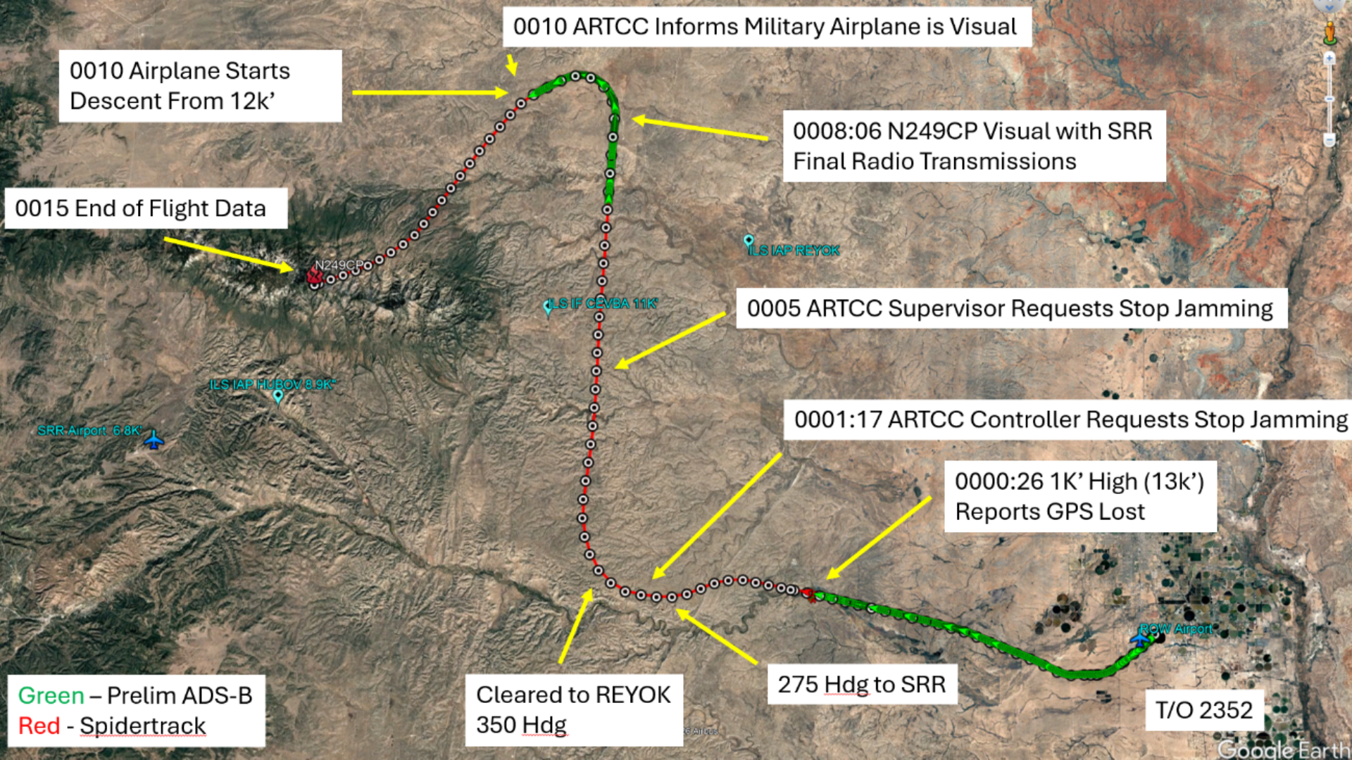
New Mexico medevac GPS jamming was reported by a flight crew shortly before their aircraft hit terrain near Ruidoso, but the available evidence does not establish that military activity caused the crash. Tom's Hardware, citing an NTSB preliminary-report account, says controllers later asked the military to halt GPS-jamming activity as they dealt with navigation problems affecting the medevac flight and other aircraft.
The twin-engine Beechcraft King Air had departed Roswell for Sierra Blanca Regional Airport near Ruidoso in May. Wired reports that two pilots and two nurses were aboard. The crash was fatal, according to Tom's Hardware.
The record so far describes an ugly sequence, not a final allocation of blame. Tom's Hardware says the crew told Albuquerque Center around midnight that it had lost GPS capability after controllers advised that the aircraft was 1,000 feet above its assigned altitude. The pilots said they were correcting and asked for a heading. Controllers issued headings toward the destination.
What happened after the crew reported GPS loss?
About five minutes after that exchange, controllers asked the military to pause its GPS-jamming activity, according to Tom's Hardware's account of the preliminary report. The outlet says the aircraft's GPS equipment resumed normal recording at about 12:07 a.m.
Roughly a minute later, the crew reported that it had Ruidoso in sight and switched to visual flight rules, Tom's Hardware reported. That change placed the crew on visual cues for the approach after controllers had been providing headings.
GPS is a receive-only satellite-timing system that lets a receiver calculate its location. GPS finds you by timing satellite signals. In this flight, the documented operational response after the GPS-loss report was controller-provided headings, followed by the crew's transition to visual flying after its instruments resumed recording.
Clear weather did not mean an easy approach
Tom's Hardware describes clear weather but a dark, moonless night. Those are very different facts: a cloud-free sky does not illuminate ridges and rising terrain beneath an aircraft. The outlet says the King Air ultimately struck terrain in the Capitan Mountains area while approaching Sierra Blanca Regional Airport.
Its account says several other aircraft also reported navigation-system issues consistent with GPS jamming, and that air traffic control was assisting other disrupted flights at the time. Those reports put the medevac crew's navigation problem in a broader operational incident, but they do not settle why the aircraft hit the mountain.
Tom's Hardware says a final NTSB report was not yet available and that the ultimate cause could not be determined. Its discussion of visual illusions, cockpit workload and route choices is analysis of the preliminary account, not a final agency finding. The defensible conclusion for now is narrower: military GPS-jamming activity was under way, the crew reported losing GPS, controllers intervened, and the flight later crashed in mountainous terrain.
This story draws on original reporting from Tom's Hardware.