Google Earth AI satellite images are now a live concern for verification work after Google added a web feature that lets users type a prompt over a location and generate altered imagery on top of Google’s existing map view.
Google introduced the feature Thursday. The company said in a public post that the tool is powered by its Nano Banana model. In practice, according to tests by 404 Media and posts from open-source intelligence researchers, a user can select a place in Google Earth’s web version and ask the system to insert objects or events that were not there.
That is a problem because Google Earth is commonly used by open-source intelligence, or OSINT, researchers to compare places over time during wars, disasters and other fast-moving events. OSINT work relies on public material, including satellite images, videos, maps and social posts, then checks them against each other. If one of the most familiar map interfaces can produce plausible fake scenes, screenshots from that interface become less useful as casual proof.
Can Google Earth AI satellite images be trusted?
They now need extra checking. The issue is not that Google Earth’s underlying imagery has stopped being useful; it is that the new editing button can place synthetic content into a recognizable Google Earth view, which makes a screenshot easier to misread or abuse.
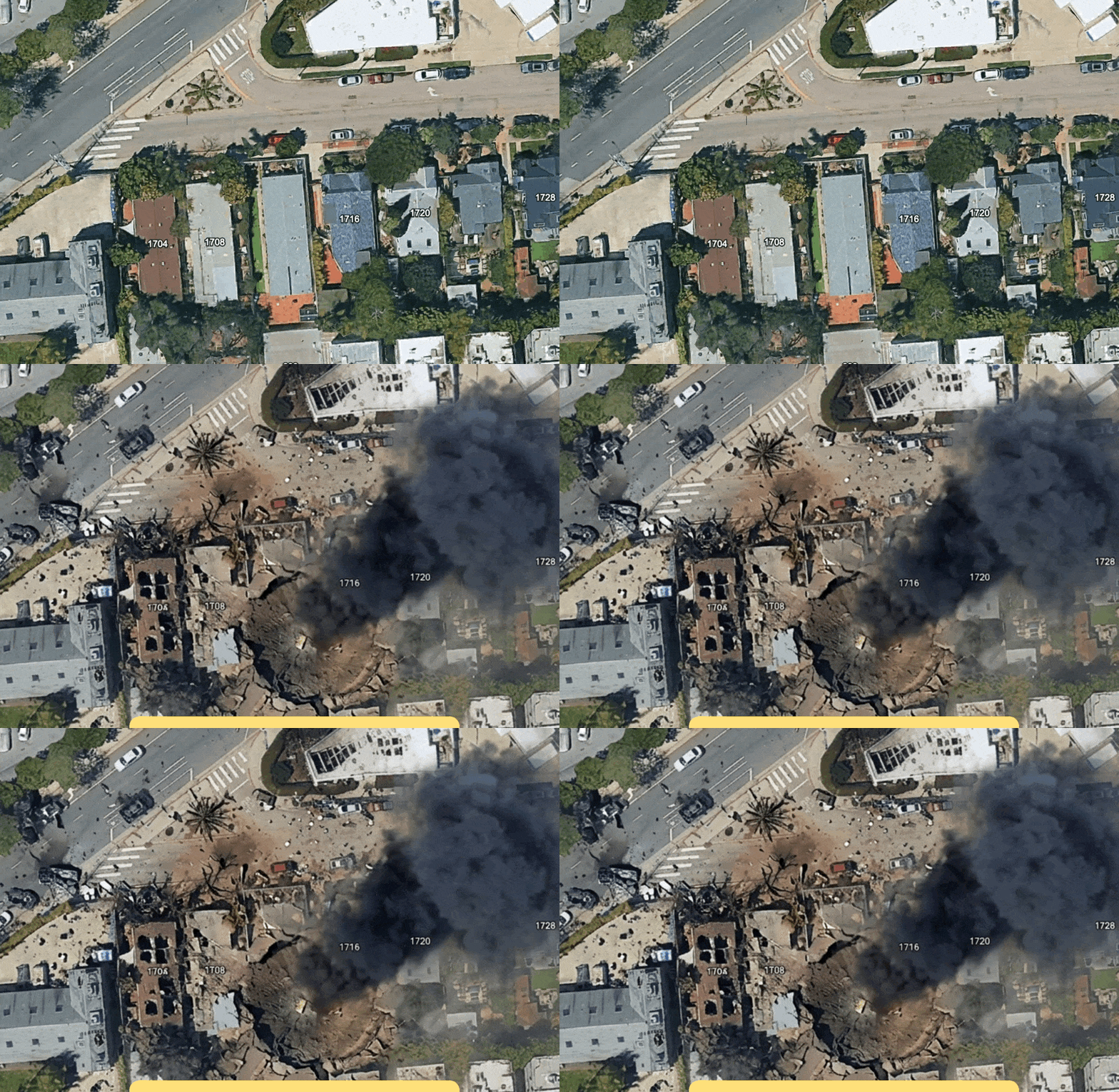
404 Media reported that its tests were able to add high-rises to a rural area, put a “homeless encampment” into a part of Los Angeles where homelessness is politically contested, and create a “bomb blast and crater” in Los Angeles. Those examples show the obvious abuse case: a fake image can be tied to a real address, neighborhood or geopolitical claim.
Hank Van Ess, an OSINT researcher, wrote Thursday that he used one-sentence prompts in Google Earth to put refugees near the Mexican border, add a nuclear plant in Iran and show a fatal crash on an Amsterdam street. He said the generated scenes sat over Google’s satellite imagery.
Ben Heubl, another OSINT professional, wrote on LinkedIn that a user could enter a workplace address and prompt the tool to make it appear as if a drone attack happened there. Heubl said the result could resemble images associated with conflicts in Ukraine, Russia, the Middle East and other war zones. He added that the tool would make verification work harder.
What does Google say about the safeguards?
Asked for comment by 404 Media, Google pointed to a Thursday post from its News from Google account on X. The company said every image made with Nano Banana in Google Earth includes a SynthID digital watermark. Google said users who are unsure about an image can ask the Gemini app or use Lens in Search to check whether it was AI-generated.
A digital watermark is a marker added to media so software can later identify something about its origin. Google’s stated defense depends on viewers taking the extra step to run a check, and on the marker surviving whatever happens to the image after it is shared.
Google also said it blocks image creation on harmful topics and keeps updating its protections. The examples reported by 404 Media and OSINT researchers, however, show that the feature can still generate imagery with obvious misinformation value: attacks, crashes, camps, industrial sites and other scenes that could shift a public argument before verification catches up.
Heubl wrote that even if tools can detect Google-made alterations, indicators can be bypassed. That is the uncomfortable part for anyone who uses maps as evidence: the first screenshot may travel faster than the correction, and Google has just made that screenshot much easier to manufacture.
This story draws on original reporting from 404 Media.